
1. Surveying developed alongside civilization
Data obtained with measuring instruments are used to improve social infrastructure.
Surveying is a technology that uses instruments to measure the position relationships between points on land and express shapes, areas and other aspects by figures or drawings. The history of surveying dates back to ancient Egypt. The pyramids, which survive to this day, could not have been built without accurate surveying technology. The four sides of a pyramid are of the same length, and the four surfaces have the same surface area. These surfaces, which face north, south, east and west, converge at a single point while maintaining a uniform angle. This would not have been possible without accurate surveying methods.
We may assume that surveying was invented with the advent of construction and developed in parallel with civilization. Surveying instruments are used to find points on a terrain or a structure like a building. They provide measurement data necessary for civil engineering projects, maps, and other such projects requiring accurate data. Such data is used in a variety of infrastructure projects, such as the construction of high-rise buildings, roads and dams, and urban redevelopment plans. Surveying instruments are also used as quality assurance tools on building sites to verify that structures are being built according to planned specifications.
2. Principles of surveying instruments that use optical technology
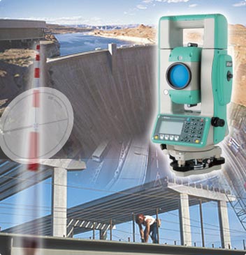
The primary function of surveying instruments is to measure distances, angles and heights. There are two types of surveying instruments used today: the total station and the GPS system. The total station employs the electro-optical distance metering method, emitting laser beams to a target and detecting light reflected off it. It takes measurements by calculating the deviation of the wavelength of the reflected light. With the GPS system, measurements are taken by receiving signals from GPS satellites. Total stations are able to measure distances to an accuracy of 2-3 millimeters per kilometer, and angles to 1-second (1°/3,600°) accuracy. One second in an angle is equivalent to the width of pencil lead at 100 meters. Even small-size surveying instruments are remarkably accurate. The two types are used according to application?total stations when extremely high accuracy is required, such as in building and bridge construction; GPS systems in applications where errors on the order of millimeters to centimeters are permitted.
Surveying instruments measure angles using a built-in encoder. The encoder is a device that measures the rotation angle and number of rotations of a built-in motor as digital data. To measure the angle to a target point, the system creates a radial pattern comprising 16,200 spokes at equal distance on a glass disc and irradiates light with an LED diode. The encoder detects the rotation angle of the motor by reading changes in the intensity of the projected light. This way, the angle to the target is detected with a resolution down to a one-second angle.
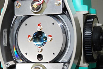
Glass disc (encoder) built in the side of the instrument
There are two methods of measuring distance: the “prism” method, which uses a reflective prism at the target measurement point, and the “non-prism,” or “reflectorless,” method that does not use a reflective prism.
With the “prism” method, a laser is beamed at a reflective prism (also called a mirror) placed at the measurement point, and the distance is measured by the time it takes for light to be reflected back from the prism. Though this method is more accurate than the “reflectorless” method, it requires the placing of a reflective prism at the measurement point, making it difficult to measure distances to high locations, diagonal surfaces, or inaccessible locations.
With the reflectorless method, it is possible to survey areas from a distant location. Even areas of possible danger such as disaster areas (e.g. landslides) can safely and efficiently be surveyed with this method, which has the additional advantage of requiring less labor and time (there is no need for a second team to handle the prism at the target point). When surveying roads, for example, traffic restrictions need to be put into place if reflective prisms are used. This is not the case with the reflectorless method. The decision to use the prism or reflectorless method is made according to conditions at the survey site.

Reflector measurement
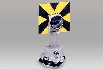
Reflector prism

Reflectorless measurement
3. Focusing system (distance measuring optics) based on proprietary Nikon technology
Nikon's total station utilizes a focusing system* for reflectorless measurement. With the non-focusing optical system, which uses fixed focal points, the width of laser beams traveling to the target is fixed. With the focusing optical system, however, the beam also changes when changing the focus of the collimating telescope built into the instrument, making the irradiated range within the field of view clear. Since there is less light reflected from the focal point, only the target is measured, even when cars or people pass through the field of view.
- *Focusing system: When measuring a distance with a focusing system, the beam that measures distance also changes when the focusing of the collimating telescope is changed, making it possible to measure the distance to the target even when other objects appear in the field of view. With a non-focusing system, however, the beam measuring the distance spreads to a fixed area, and diverges, sometimes causing the system to measure objects other than the target.
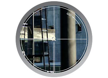
Target captured by the collimating telescope
Besides the focusing system, a number of other advanced technologies have been incorporated in today's surveying instruments. Technology that enables the manufacture and use of submicrometer (1/10,000 millimeter) parts has made it possible to develop compact, high-accuracy surveying instruments. Surveying is also possible in rain and fog, on dusty sites, and in extreme cold (-20°C) and heat (up to 50°C).
Nikon is developing products that support the “Intelligent Construction System”—a system that effectively uses various types of data obtained through various construction processes. Nikon continues to contribute to the development of surveying instruments based on its own technological strengths by offering cutting-edge products such as field computers that interact with total stations.
The principles of the focusing optical system and its advantages